

From Wattens to Geier (2857m) and Lizum Reckner (2886m) and back


Technical difficulty: 4/10 (8/10 for the summit of Lizumer Reckner)
Fitness: 9/10
Objective danger: 2/10 (7/10 for the summit of Lizumer Reckner)
Landscape: 6/10
Busy: 3/10
A long and mostly very runnable loop through two valleys close to Wattens. Good for training long stretches of running.
Starting point: Kletterarena Wattens
Ending point: Kletterarena Wattens
Length: 51km
Vertical: 3000m
Speed: A lot of forest roads and runnable trails. The summits and the first 800 verts of descent are slower technical going.
Route:
We start by following the GPS track through the streets of Wattens, out of town and to the village of Unterberg. We pass the few houses that make up this settlement and follow the paved road a little bit further. In a sharp left turn, a forest road with a gate disconnects and leads of southwards. We start off on this forest road and stick to it for quite a while. We stay on the forest road, following the river upstream for about 5km, before joining the paved road again at a big farm house. From here it is only a few hundred meters to the small group of houses - Volderwildbad - and a hiking parking lot.
From here, we keep following a well maintained forest road up the valley, always heading south, following the signs towards the Voldertalhütte (another 5km or so). The hut is a short side trip (maybe 100m) from the road and well worth the stop for some food or drinks. Our run continues further softwards, continuing up the valley, following the forest road until a small hut called Swarzbrunn. Here we leave the forest road and follow a relatively small trail following the stream uphill, first gently and later on quite steep, before connecting to the forest road again.
We can catch a breath on a flatter section before we start climbing steeper towards the Steinkasernalm. The small group of huts has drinks waiting for you in the water source (2-3 Euros at the time of writing). We keep going southwards towards the end of the valley for another 500 verts or so. The trail gets steeper before finally reaching Naviser Jöchl. We follow the ridge to the south-east/east towards the next saddle at Mölsjoch and traversing the south side of Mölser Sonnespitze. There a trail leaves steeply down south-west into the Navis valley.
Here the technical parts of the route start. We descend through alpine meadows all the way to Obere Knappenkuchl. We traverse the valley upwards south-east towards the ridge between Naviser Kreuzjochl and Geier. From the ridge we turn north-east, cross a steep traverse under a steep rockwall, pass by a small lake - Staffelsee and ascent further through a scree field towards a saddle.
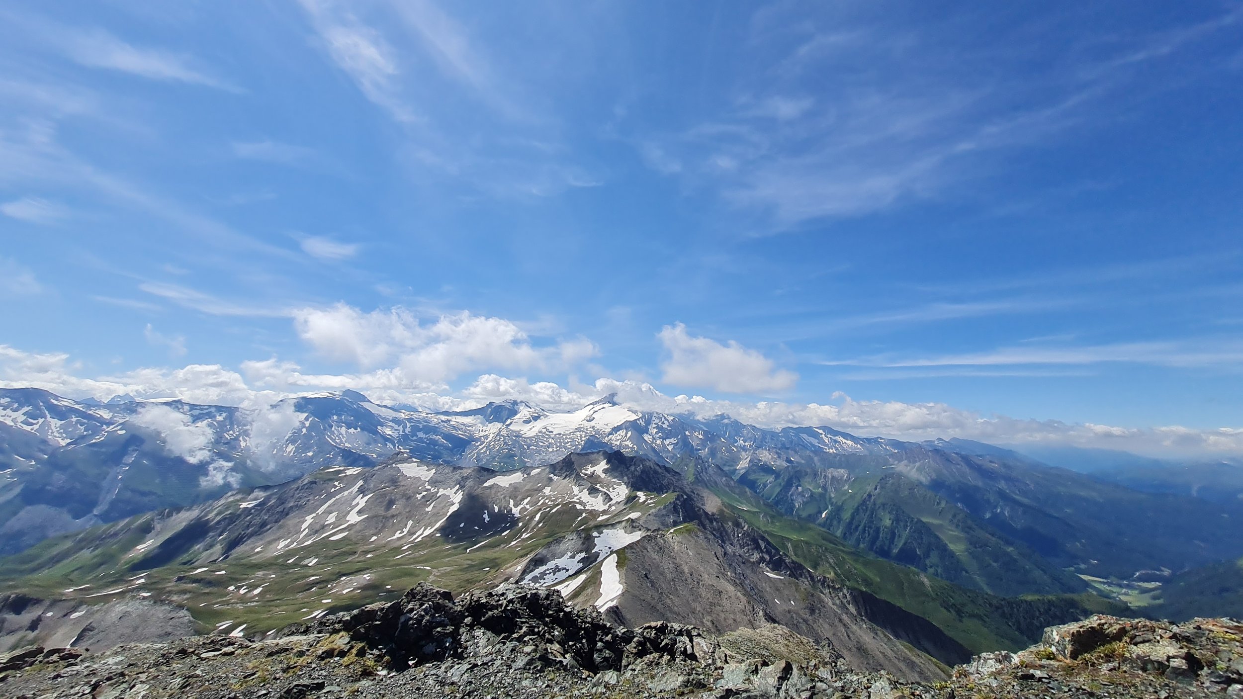
From here, we go first left (north), scrammbling along the ridge on some fixed ropes and steps towards the summit of Lizumer Reckner (2886m). After descending the same way back to the saddle, we continue on the ridge south for a few hundred meters towards the summit of Geier (2857m) as well. Much less interesting, but with a metal vulture statue on the top. This is a much less interesting summit, but offers amazing views far and wide.
We start the technical descent towards the Wattens valley. First following the ridge further east towards Geierjoch for a bit, before starting the descent north steeply into the valley. The trail is steep and full of loose rock, leading through some prime skiing terrain for the winter. Soon a hut and the military training area become visible down in the valley. We continue down on seemingly endless trail before reaching the valley floor and a forest road leading to the Lizumer Hütte. Another great place to stop and have a break.
The trail is mostly downhill from here. First we follow the right side of the valley down on about 6km of really flow-y trails until reaching the parking lot for the hut. From there the route becomes a bit of a grind and a test of mental strength. It is very runnable, with few rolling hills, mostly following a forest road back to Wattens. As we continue, the valley gets continuously wider and the route less interesting. Before doing the last 3km on a bob track back to town, making you happy to be back where you started.
Pro tip: there is generally plenty of water everywhere on the route. Plenty of streams to refill from.
Pro tip #2: bring cash for the huts.
Photos by @bennibru and @the.running.nomad